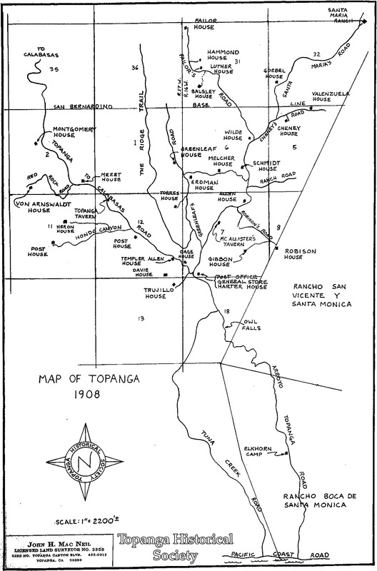
Map of Topanga homesteads in 1908
Title
Map of Topanga homesteads in 1908
Description
A map of homesteads in 1908 along Topanga Canyon Blvd. and Old Topanga Canyon Road, drawn by John H. Mac Neil, Licensed Land Surveyor: Hiram Montgomery, Tony Von Arnswaldt, Frederick Mazet, Topanga Tavern, John Heron, Frederick Post, Templer Allen, Francisco Trujillo, H. R. Gage, William Gibbon, Stella McAllister, Joe Robison, Charles Greenleaf, Felipe Torres, Ed Erdman, George Melcher, Wilde, August Schmidt, Columbus Cheney, Marseano Valenzuela, Jesus Santa Maria, John Goebel, Hammond, Luther, Ben Balsley, Benjamin Failor, Potter's Trading Post, Elkhorn Camp.
Date
1908
Source
VF Maps
Rights
Materials in this collection may be protected by the U.S. Copyright Law (Title 17, U.S.C.). In addition, the reproduction of some materials may be restricted by terms of Topanga Historical Society gift or purchase agreements, donor restrictions, privacy and publicity rights, licensing and trademarks. Transmission or reproduction of materials protected by copyright beyond that allowed by fair use requires the written permission of the copyright owners. Works not in the public domain cannot be commercially exploited without permission of the copyright owner. Responsibility for any use rests exclusively with the user.
Creator
John H. Mac Neil
←Next Item
Previous Item→
Previous Item→
Citation
John H. Mac Neil, “Map of Topanga homesteads in 1908,” Topanga Historical Society Digital Archive, accessed April 18, 2024, https://www.topangahistoricalsociety.org/archive/document/978.
